|
|
Post by fiona on Apr 13, 2011 19:04:50 GMT -5
You could be right about that Labor Temple. So that side street would be Deveruex Street? I also see a little restaurant up there "CAFE". Would you say this is about 1928?
|
|
|
|
Post by fiona on Apr 13, 2011 19:10:45 GMT -5
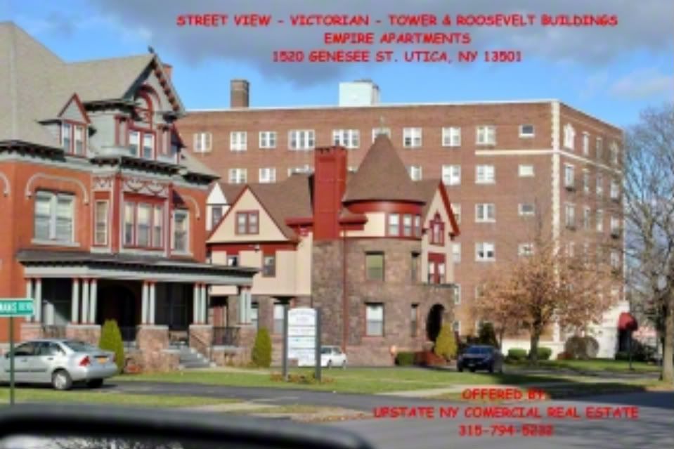
Alao, I can point out that the Roosevelt Apts and the Algonquin Apts, both on Genesee Street, have the same structural styles, the same moldings, details, brick and stone work and were both built around 1928. See if you can google earth either of these buildings and post it? the Roosevelt ( now Empire Apts) is on the corner of Watson and Genesee, the Algonquin across the road from the Olbiston.
|
|
|
|
Post by fiona on Apr 13, 2011 19:21:18 GMT -5
This is a sweet view because it clearly shows the Empire Apts ( large building on the corner) and you can see some of the detailing for comparison. The other two mansions are the homes of the Baker Brothers, the owners of the Saturday Globe. They are all owned by one firm and they are kept immaculate.  |
|
|
|
Post by fiona on Apr 13, 2011 19:26:51 GMT -5
For a quick check of what used to be on this corner go to "A New Sketch Of Old Utica,"
|
|
|
|
Post by Dave on Apr 13, 2011 21:02:24 GMT -5
Dave: So sorry. I took your 2 new birds eye views down by mistake. I mean to take mine down. i will take mine down now. Please replace yours. Sorry. OK, I'll put them back up when I get to my other computer. It's easy to mess up in admin mode. I do it all the time. |
|
|
|
Post by Dave on Apr 14, 2011 18:35:57 GMT -5
Here they are.  Taking the top photo, enlarging and sharpening it: Taking the top photo, enlarging and sharpening it:(You can see the green foliage begin at the Savings Bank, the dome of which doesn't look gold, does it. I wonder if the gold layer on the dome was a later touch or if the person who colorized the photo just skipped it.) 
|
|
|
|
Post by fiona on Apr 15, 2011 22:40:33 GMT -5
nice. thanks.
|
|
|
|
Post by fiona on Apr 24, 2011 11:31:52 GMT -5
hello all. I am working on this steady as she goes. Today I put up 3 views for your enjoyment. I am limited now by other projects to an hour or so a day. Will try to put up more tonight.
|
|
|
|
Post by Dave on Apr 24, 2011 18:54:39 GMT -5
Very nice, Fiona. Thanks. I hadn't seen those shots.
|
|
|
|
Post by fiona on Apr 24, 2011 19:06:31 GMT -5
Thanks. Iv'e moved over to South Street now. Did you like the card of the elms? Doesn't say what cross street that is, but I think It's part of the old Bleecker farm. Beautiful.
|
|
|
|
Post by Dave on Apr 25, 2011 0:00:32 GMT -5
Loved it. That's quite a slope on the street running down and away from us. Not steep enough for the photographer to be standing on the Parkway, but too steep for any other section I can think of. Seymour does run down from South to Rutger, but my memory of the area from walking there as a kid is that from South the street doesn't immediately descend, but rather it begins to drop half way through the block on the way to Rutger. Where was the Bleecker farm?
|
|
|
|
Post by Dave on Apr 25, 2011 0:31:00 GMT -5
A little research. We don't know the date of the post card photo (do you?), but here are panels from the 1883 map of Utica, followed by the explanation of symbols. The first is of the corner of Seymour and South, then Seymour and Arthur and last is Seymour and the Parkway.      On the map there is a brick building on the northwest corner of South. On the corner of Seymour and Arthur a number of homes line Seymour running north. And also on the map, on the corner of the Parkway and Seymour there is a barn on the corner, just as there is in the photo. And a permanent home across the street, which can be just seen inside the frame of the photo. So if there were few or no changes between the time the photo was taken and the 1883 map, I'd say the photographer was standing on the Parkway looking north down Seymour. But the slope still seems wrong. It's possible, of course, he was over on the Parkway and Miller or West Streets .... on the wrong corner ... when he took the shot. Or the optics may have simply yielded a gentler slope than is in my memory. |
|
|
|
Post by fiona on Apr 26, 2011 20:34:55 GMT -5
You know, you may be right about the photographer standing on the Parkway and looking North. I never thought of that. The card was printed about 1900- 1910. That was the heyday of picture postcards. Let's think about this: If the photog was standing on the corner of Eagle or South, it would not have been so rural looking in 1900. Cornhill was somewhat built up by then. Yes? However, the Parkway was Not. Most of the homes on upper Seymour, that hill that goes up to the Parkway were built around 1930 and after that. So, your hypothesis makes sense to me. As I look at the picture I also see the road going north is undeveloped. that makes sense also. I don't know much about the Bleecker farm, but at one time it did extend to the Parkway, which was kind of the "city line." These trees are mature. They have to be at least 30 to 50 years old. By 1880 Seymour was a worn out old man and he was also ill. So, yes, I believe you are right. the maps are beautiful also. I have about 10 more post cards to go, then you can start loading the maps into the threads. I am also researching the genesis of street names over at OCHS and have some of that ready to go. this chapter is going to be a little different. Keep in touch. I am working on it as much as I can.
|
|
|
|
Post by fiona on Apr 30, 2011 22:07:00 GMT -5
Dave: working on the thread tonght. I am going now to simply post the cards, view them and them rearrange them into the story. I think that's the best way.
|
|
|
|
Post by fiona on Apr 30, 2011 22:24:14 GMT -5
Found  this and I love it! |
|